 "Spanfeller is a twat" (theaspiringengineer)
01/15/2019 at 23:55 • Filed to: DID I EVER MENTION I'M A MAP GEEK?
 4
4
 25
25|
"Spanfeller is a twat" (theaspiringengineer)
01/15/2019 at 23:55 • Filed to: DID I EVER MENTION I'M A MAP GEEK? | 4
| 25 |
Thoughts?
The roundabout in the center is Insurgentes, top left (near the big park) is Bellas Artes, further up from there is the “zocalo”
Lower center are two sections of Chapultepec park, the three large buildings in it are, the Castle, the Anthropology Museum, and the National Auditorium. To the right of the auditorium the building complexes belong to the La Hormiga Ranch. The previous presidential residence. A bit further up is Parque Mexico, completely surrounded by Amsterdam Avenue. The smaller section is Parque Espańa. Mid right is (if am not wrong) a huge medical complex. The big avenue staring at Chapultepec and ending on the top left of the map is Reforma.
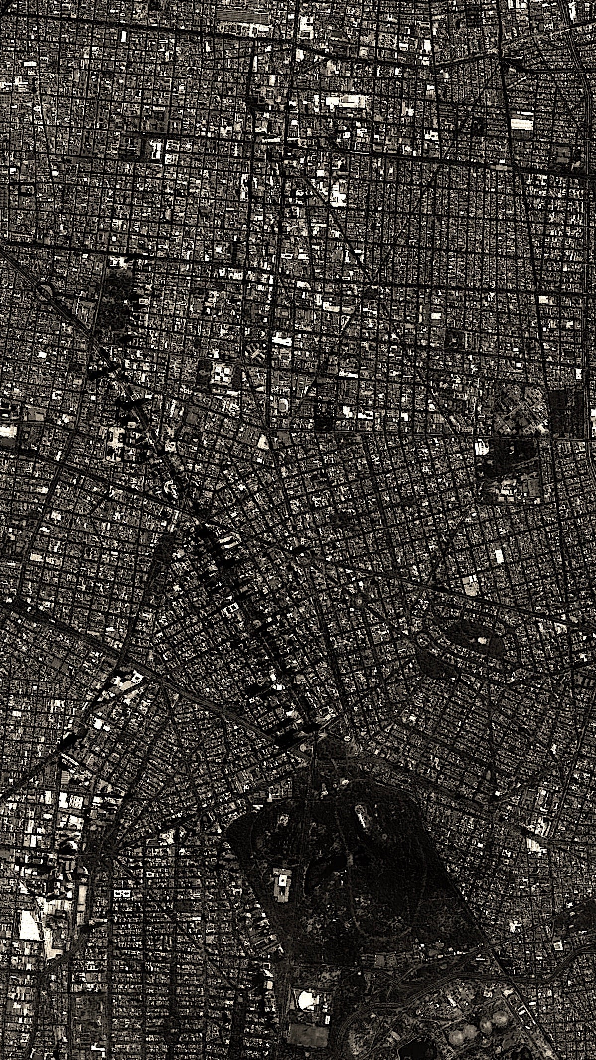
National Geographic said Mexico City is the best place to visit in 2019. Which is interesting because I’d wager 90% of tourists to Mexico City want to stay inside the areas of the map I’m showing.
 TheRealBicycleBuck
> Spanfeller is a twat
TheRealBicycleBuck
> Spanfeller is a twat
01/16/2019 at 00:04 |
|
Maps are among my favorite things. Two thumbs up from me.
|
Spanfeller is a twat
> TheRealBicycleBuck
01/16/2019 at 00:08 |
|
It’s actually an older satellite photo, cus the newest one had some weird lighting
 gmporschenut also a fan of hondas
> Spanfeller is a twat
gmporschenut also a fan of hondas
> Spanfeller is a twat
01/16/2019 at 00:33 |
|

Mmm
 Spasoje
> Spanfeller is a twat
Spasoje
> Spanfeller is a twat
01/16/2019 at 01:45 |
|
P
erfection. I have the same basic wa
l
l
p
a
p
e
r
,
j
u
s
t
o
f
a
s
a
t
e
l
l
i
t
e
v
i
e
w
o
f
B
e
l
g
r
a
d
e
i
n
s
t
e
a
d
!
 BJ
> Spanfeller is a twat
BJ
> Spanfeller is a twat
01/16/2019 at 07:04 |
|
That’s nice, maps are fun . It's Google Maps with some basic colour and light adjustments?
|
TheRealBicycleBuck
> Spanfeller is a twat
01/16/2019 at 07:35 |
|
Well, if you’re going to be that way, it’s probably a satellite image , not a photo unless you managed to get declassified spy photos. Photographs require film and only the earliest systems actually used film. ( https://motherboard.vice.com/en_us/article/jpzpkg/the-first-spy-satellites-had-to-drop-gigantic-buckets-of-film-back-to-earth )
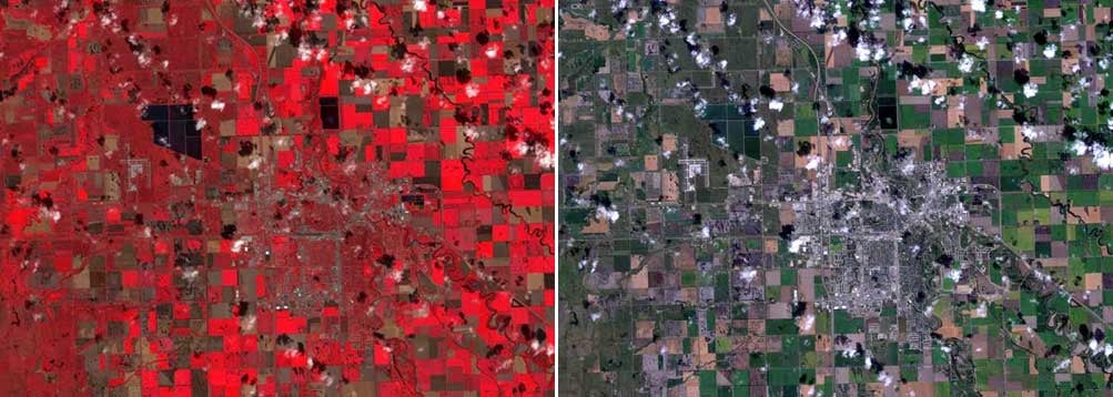
Weird lighting? Perhaps it was false-color infra-red. This technique substitutes red for infra-red and shifts the other colors in the spectrum. It’s used to monitor vegetation growth. Pinks/bright-reds are actively-growing young vegetation, darker reds are mature vegetation. In this sample, it’s easy to tell the difference between young crops, old crops and pasture land, and plowed fields.
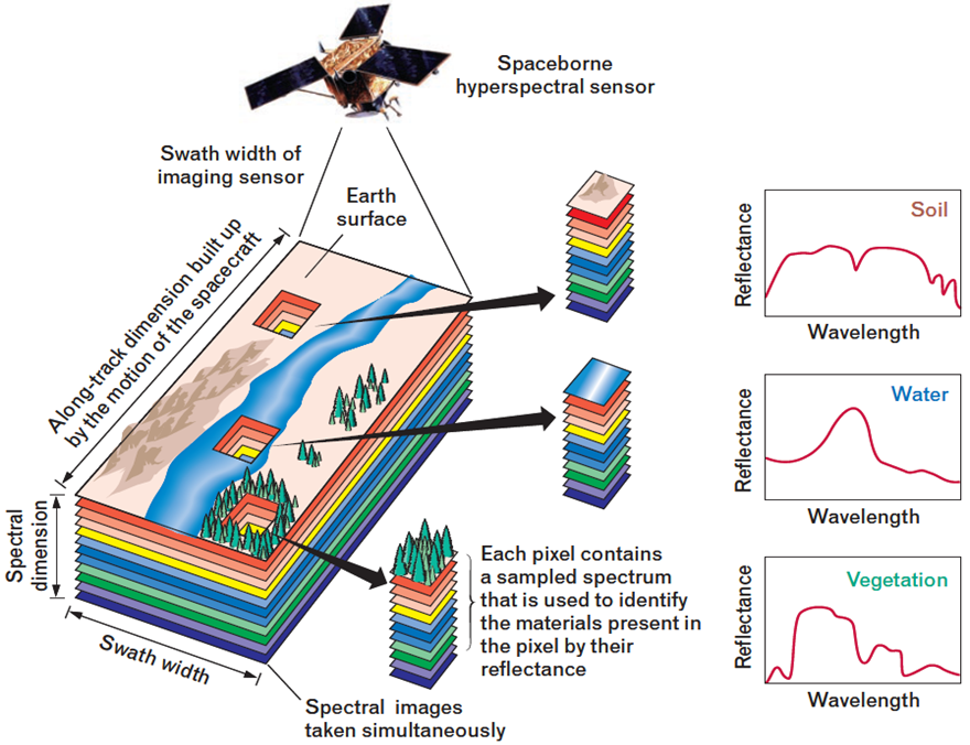
Take it a few steps further and you get hyper-spectral imagery. Instead of four bands of information, there are 256. This allows for much more detailed analysis. In farming, it’s used to identify soil composition in freshly plowed fields. In forestry, it can be used to identify different species of trees and can identify trees that are unhealthy, perhaps due to beetle infestations.
I’ve used four band and hyperspectral data to classify land cover types in a number of projects over the years. It’s neat stuff.
 davesaddiction @ opposite-lock.com
> TheRealBicycleBuck
davesaddiction @ opposite-lock.com
> TheRealBicycleBuck
01/16/2019 at 09:11 |
|
“p hotographs require film”
You’re saying no one makes photographs anymore?
|
TheRealBicycleBuck
> davesaddiction @ opposite-lock.com
01/16/2019 at 09:24 |
|
No, I’m saying satellites don’t use film any more, so the right term is imagery, not photo. We could also go into the different methods for collecting imagery, but that’s getting pretty deep.
|
davesaddiction @ opposite-lock.com
> TheRealBicycleBuck
01/16/2019 at 09:35 |
|
When the word photograph was first coined, it was on film, but I don’t think anyone’s trying to relegate that word to the history books now that 99% of photographs are captured digitally.
 ttyymmnn
> davesaddiction @ opposite-lock.com
ttyymmnn
> davesaddiction @ opposite-lock.com
01/16/2019 at 09:51 |
|
You’re saying no one makes photographs anymore?
Not from space.
|
davesaddiction @ opposite-lock.com
> ttyymmnn
01/16/2019 at 10:12 |
|
It’s all just data gathering and replication in pixel form . Is there some material difference between the images gathered by the sensor in a satellite vs. the images taken by the sensor in my phone or camera? Clearly the sensors in the satellites are more advanced and are gathering much more data (wider spectrum) , but the human eye can only see so much . What difference is there if the image is gathered from space, or from an airplane ? Why can’t the replication of either, printed or on screen, be called a photograph?
|
Spanfeller is a twat
> gmporschenut also a fan of hondas
01/16/2019 at 10:12 |
|
I’d guess that would be Guadalajara
|
ttyymmnn
> davesaddiction @ opposite-lock.com
01/16/2019 at 10:17 |
|
I’m running with Buck’s argument. However, “photograph ” simply means “recorded light” and, no matter how you capture an image, it can be called a photograph. It does not require printing, nor does it require a physical media like film. You are capturing light at a given moment and presenting it.
|
TheRealBicycleBuck
> davesaddiction @ opposite-lock.com
01/16/2019 at 10:55 |
|
In the world I work in , the words have distinct meanings, especially when it comes to imagery. It tells us a lot about how it was captured and how it will have to be processed to make it useful.
It’s like calling a truck a car. Two different things. Two different purposes.
|
davesaddiction @ opposite-lock.com
> TheRealBicycleBuck
01/16/2019 at 11:07 |
|
Okay, I can see that. Do you use photographs at all anymore ? Do aerial photography folks still use film?
|
TheRealBicycleBuck
> davesaddiction @ opposite-lock.com
01/16/2019 at 11:34 |
|
Using photographs for photogrammetry is a dying art, primarily because all aerial imagery is captured digitally. When captured digitally, sensors on the aircraft and in the camera can automatically account for horizontal and vertical position as well as rotation in all three axis. During post processing, software takes that information along with details about the camera (known lens distortions, focal lengths, etc.) to automatically correct for parallax errors, automatically generate digital elevation models, and even automatically build 3-D models with a little input from a technician.
The old-school photogrammetry course at my university was dropped because they saw no need to teach those skills any more. It was replaced with a course on digital imaging.
|
davesaddiction @ opposite-lock.com
> TheRealBicycleBuck
01/16/2019 at 11:42 |
|
I learned about some of this stuff during my post-grad GIS certificate coursework with Penn State. Our main software we use is industry-specific, but damn is it nice to have Digital Globe’s data on-demand and auto-georeferenced in our map program. So easy to see potential surface use issues, and great for confirming accuracy of section lines in our landgrid/survey data.
|
TheRealBicycleBuck
> davesaddiction @ opposite-lock.com
01/16/2019 at 11:58 |
|
This statement concerns me a bit: “...great for confirming accuracy of section lines in our landgrid/survey data.”
As long as you are looking at general trends, that’s ok. Just remember two things: aerial imagery is considerably less accurate than survey data; and boundaries and section lines are legal constructs, taking precedence over aerial imagery.
That being said, I
regularly
use
imagery and LiDAR data to cross-check survey
data. T
he
worst surveyor we had made a truncation error in his calculations, throwing all of his lines about 15' off, then his technicians accidentally swapped their poles and didn’t reset their data collectors to account for the height difference. Their profiles were 1.5" too high on one side of the levee and 1.5" too low on the other. The guy didn’t believe me at first, but when I told him the probable cause of the error and how he could prevent it from happening again (set both poles to the same height and instruct the survey techs to adjust the data collector mounting point as needed), he finally realized that I kne
w what the hell I was
talking about.
I used to teach GIS, GPS and Remote Sensing in graduate and undergraduate programs.
|
davesaddiction @ opposite-lock.com
> TheRealBicycleBuck
01/16/2019 at 12:19 |
|
Yeah, just trends. The land grid data from IHS is okay, but not great, and we take the corners from our survey plats and correct them. The sat. imagery is a good sanity check on the survey data. If the roads line up well with the corrected section lines, I know we’re good to go. If they’re way off, I know I need to check with our surveyor to make sure they didn’t screw up something on the plat (has only happened a couple times).
Wow, that’s not good... I’ve had those types of moments myself. When I start talking about datum, projection, true north vs grid north, etc., the person on the other line either knows we can communicate, or knows they need to go get someone who can - ha!
That’s cool that you used to teach. My path is really weird: I started off taking drafting in HS, then chose engineering (probably should’ve done architecture) where we took surveying and learned CAD , then decided engineering wasn’t for me and ended up getting a BFA in graphic design. Moved, had a shitty job for a sign shop, had a neighbor who was a geologist that encouraged me to apply for a technician job at his company. Got it, started learning (software has always come easy for me), got laid off, got a new job, kept learning (and went back for the GIS certificate). Have been at it for almost 15 years now. Wish I was more proficient at ArcGIS - I’m decent, but just don’t use it as much at the smaller company I’m at now (we use IHS Petra - old school, like a 5 lb sledge compared with the 6-axis machine of Arc). Definitely can’t complain, though. I’ve had more success down this path than I ever could’ve imagined while I was languishing at that damn sign shop...
|
TheRealBicycleBuck
> davesaddiction @ opposite-lock.com
01/16/2019 at 14:01 |
|
Thanks. I finished a B.S. in Marine Biology (thanks for the inspiration, Jacques ), realized I didn’t want to do the real work in that field, spent time doing research in medicine, went back for a masters and Ph.D. in planning-related fields where I learned GIS, started teaching and doing research, then left for the private sector where I could do disaster recovery work (my dissertation focused on disaster prevention through planning).
ArcGIS is a fine set of tools. My job would be a lot harder without them, especially the tools they provide for spatial analysis and statistics, something most users would never touch. GIS as an industry is extremely segmented because of the wide variety of work that’s out there. Most users never stray very far outside their particular kind of work. One of the best things about teaching was having to become proficient in a variety of fields so I could teach the students how to use it in their industry, whether it was forestry, wildlife manage ment, urban planning, surveying, marketing, or disaster recovery.
|
davesaddiction @ opposite-lock.com
> TheRealBicycleBuck
01/16/2019 at 15:15 |
|
I wonder how many older GIS folks have similarly circuitous paths?
I’d love to become a true master of the “toolset” one day, as well as get some Python under my belt. I should actually have some time to pursue this over the next several months (we’ve slowed down a bit); we’ll see if I can work up the proper motivation.
|
TheRealBicycleBuck
> davesaddiction @ opposite-lock.com
01/16/2019 at 15:47 |
|
I find that I can usually cobble together what I need through the plethora of Python examples online. I’ve been through a couple of different Python classes to get the gist of the layout, but I’m old enough to know I won’t be coding a bunch of Python from scratch without references.
The Udacity Python courses are pretty good. The Udemy courses are hit or miss, depending on the instructor.
Most of the older GIS folks came into it through their work and really only know enough to do their jobs. As a member and representative of GISCI, I’ve had that conversation with a lot of old timers. Most of them are pretty
miffed that they won’t be able to meet the minimum qualifications for the GISP certification.
|
davesaddiction @ opposite-lock.com
> TheRealBicycleBuck
01/16/2019 at 15:58 |
|
Do any old-timers really need a GISP anyway? Nice to have on the resume, for sure, but s eems like experience usually trumps certs, unless of course you’re up for a job against others with similarly long experience (or switching disciplines).
|
TheRealBicycleBuck
> davesaddiction @ opposite-lock.com
01/16/2019 at 16:04 |
|
Many government contracts are requiring a GISP on the team, so a lot of old-timers are looking for the cert so their company can compete.
|
davesaddiction @ opposite-lock.com
> TheRealBicycleBuck
01/16/2019 at 16:18 |
|
Ah, yes - I can see that.